Showing posts with label Publication Samples. Show all posts

Wednesday, 26 October 2022

The Three Jolly Crofters and the Scowcrofts

Extract from Bradshaw Chapel II by James Francis, pages 13-15, Bradshaw Chapel Area 1800-1900.

A deed of 22nd December 1802 details the lease of one acre (being a Cheshire acre this would be equivalent to 2¼ statute acres) of land called Blunder Hillock by John Isherwood of Marple Esq (the Lord of the Manor) to John Scowcroft of Bradshaw, cotton spinner, at the yearly rent of £9-9s-0d on the lives of John Hamer (age 15) Robert Hamer (age 12) and Andrew Hamer (age 7) sons of Mary Hamer, widow of James Hamer of Bradshaw. 

This piece of land was immediately behind the Ramsden’s building on the corner of Lee Gate and was part of the larger Morts Hill area. Unfortunately, there is no plan with the deed, but it encompasses the area on which a cottage was subsequently built between the old Lee Gate Bleach Works and the Lee Gate farm/cottages, as well as the land on which the three storey works/farm building was eventually erected at Back Bradshaw Chapel - probably for John Scowcroft’s spinning business. Both these buildings enjoyed a common access from Bradshaw Road. 

Thursday, 24 March 2022

Early Development of Bradshaw Chapel 1700 - 1800

Extract from Bradshaw Chapel I by James J. Francis, chapter 2, pages 5-8.

Chapter II - Early Development of the Chapel 1700-1800 

In 1704, a special fund was established to receive and use the ecclesiastical dues previously annexed by Henry Vlll and which were then the property of Queen Anne, to supplement the incomes of the poorer clergy. The fund was known as Queen Anne's Bounty. Parishes were able to apply for a grant on the basis that the Bounty grant would be equalled by the Diocese and the total used to invest in property to produce an annual income for a deserving Curacy or Chapelry. 

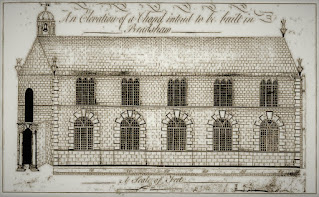
Bradshaw Chapel Plan Elevation 1774
Drawing of new Chapel proposed by Petition in 1774 - Elevation.

Monday, 24 January 2022

Seventeenth Century Disputes over Edgworth Moor

Extract from the Enclosure of Edgworth Moor by James J. Francis, chapter 3, pages 6-7.

Edgworth v Entwistle, 1672

Due probably to the passage of time with no adequate records, there appears to have been much disagreement and wrangling over the rights of common on Edgworth Moor between the property owners of Entwistle and Edgworth.

Over 400 years had elapsed since Entwistle had been separated from Edgworth, but the Entwistle property owners had persevered in maintaining their ancient ‘rights of common’, while the Edgworth freeholders saw no logic at all in 'outsiders' having rights to their Edgworth Moor.

Townships of Bolton-le-Moors
The townships of Bolton-le-Moors
Entwistle, Edgworth and Quarlton outlined in red

Monday, 3 January 2022

The Division of Hardy Mill and Heatons

 Extract from Hardy Mill by Fred Horridge, pages 23-26, Chapter 8.

The Estate Divided

The year 1745 was important to this history in that it was then that Hardy Mill and the Heaton's Farm became divided into two separate holdings. Figure 10 shows the layout of the estate at that time with the names and acreages of the fields. Some conflicting acreages are stipulated in the Abstract of Title but the total area of the original estate was a little over 29 Statute Acres (R15.)

Plan of Hardy Mill and Heatons c1745
Fig. 10 - Plan of Hardy Mill and Heatons c1745
Showing layout, names and statute acreages of fields.

Tuesday, 5 October 2021

Datestones of Bradshaw and Harwood

Below is a selection of photographs from our publication #11 Datestones of Bradshaw and Harwood. The book contains details of 49 datestones and is annotated with information about the buildings they are attached to.


12. Lower Knotts - George & Rachel Heaton 1795

Monday, 9 August 2021

Bradshaw Works Extensions

Extract from Bradshaw Works by J J Francis, Chapter 11, pages 38-42.

By the 1850s, the works had grown considerably and we are fortunate in having a plan of 1853, showing the southern section of the Works. 

The original bleach croft to the north east of the site remained as the Old Croft or Higher Bowk House, but an additional Lower Bowk House now supplemented the previous bleaching capacity. This was housed in the extended main block adjacent to the river. The Dye Houses had also been extended. 

Bradshaw Works

Wednesday, 2 June 2021

Prehistoric and Roman Turton

Extract from Turton through the Ages, Chapter 3, pages 9-11.

As we anticipate the third millennium AD, it is a tempering thought to reflect upon what aeons of time man and his ancestors roamed the uplands of Turton in times BC. Prehistoric dates are notoriously difficult to establish but throughout our lifetimes these dates have been pushed further and further back by each scientific advance. Finds of shaped flints on the Bolton moors tell us that early hunters roamed these hills. With the coming of metals and the easier felling of trees the hunter-herdsmen could settle into communities and have time and resources enough to cooperate on the building of megalithic monuments. The earliest in our area is the Pikestones on Anglezarke moor, the remains of a five slab burial chamber of an unusual type unique in Lancashire. The nearest similar chambered long cairns are in Derbyshire and Southern Scotland which points to the slow spread of a common culture even in these early times. So too with the spread of knowledge of metal working. Finds of bronze implements have been recorded at Charters Moss, at Edgworth and at Belmont. Pottery techniques improved and a large pot now in Bolton museum came out of the Noon Hill excavation in the 1950s. Very fine pots of the same period can be seen in Darwen library. They came out of an excavation at Whitehall, Darwen which is very close to our Turton area. 

Plan of the Stone Circle discovered on Chetham Close,
near Bolton Drawn by Gilbert J French, 1894. 

Wednesday, 19 May 2021

Members of Harwood Temperance Sick and Burial Society, 1836

Extract from Harwood Friendly Societies by J J Francis, Chapter 4, page 8.

The surviving records confirm that the first year of operation of the Harwood Temperance Sick and Burial Society was from August 1836, starting with 28 members, these being:

Sunday, 2 May 2021

Victoria Mill - The Last Working Mill in Turton

An extract from People and Places of Turton, part 4, pages 57-59.

The Haworth family sold Victoria Mill (the first documented use of the name) on 9th March 1902 to John and Thomas Brooks, co-partners in the towel manufacturing business of Brooks Bros who were at the time of purchase already established at Victoria Mill. Brooks Bros had also been operating as towel manufacturers since 1891 at Crown Mill, Hawkshaw, Tottington based originally on the site of Kenyon’s Farm.

John & Sarah Alice Brooks outside their Victoria Mill cottage c1910

Tuesday, 23 March 2021

The Final Stages of Horrobin Mill

Extract from Horrobin Mill by J J Francis, Chapter 6, pages 27-34.

After the death of the last of Thomas Appleton's family, the Trustees of the Estate arranged for an auction of all their properties on October 28 1903, to be held at the Public Sale Rooms, Bowkers Row, Bolton, by Lomax Sons & Mills.

'HORROBIN MILLS - A Valuable Bleaching, Dyeing and Finishing Works with Extensive Water Rights' was offered as a going concern with the goodwill of the business. 

Horrobin Mill 1960
Horrobin Mill looking towards St Annes Turton in 1960
Horrobin Fold is centre left and Lees Cottages at centre right
behind the bleachworks buildings

Wednesday, 24 February 2021

The Bradshaw Floods of 1980 and 1986

Extract from The Bradshaw Flood, 'Other Bradshaw Floods', pages 40-41. 

1980

The Bolton Evening News of 23 October 1980 reported torrential flood waters sweeping through Bolton after nearly two inches of rainfall. Bradshaw Road was almost impassable under fast flowing waters, two feet deep in places, which ran down the road towards Lea Gate. Police were present controlling traffic. Workmen were employed to unblock a tunnel under Bradshaw Road at the old works’ gates. Mr Maurice Danials of Bradshaw Road said he ‘had lived on the road for fifty years and had never seen anything like it’.

Bradshaw Bridge in 1980

Saturday, 16 January 2021

Springside Papermill, Belmont

Extract from Eagley Brook by Helen Heyes, Chapter 7, pages 31-33.

A goit which wends its way from the Ornamental Reservoir around the hillside, following the contours, leads to yet another small reservoir or lodge which supplies Springside Paper Mill, where paper has been made continuously since 1834 to the present day. Other reservoirs near the mill are supplied by Three Nooked Shaw Brook, which rushes down from Smithills Moor in a series of waterfalls and weirs. One day's water consumption at this mill is said to be in the region of 1.5 million gallons.

Map showing Charles Turner
Springside Paper Works 1927.

Wednesday, 7 November 2018

Toby Inn, Broadhead Road, Edgworth

Extract from Pubs in Turton 1 by John Barlow, pages 31-33, Chapter 2.  Edgworth


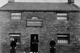
The first record dates back to 1825 when Richard Ward was the Licensed Victualler. During its long history it has had several names starting with the Dog and Moor Game in 1825. In 1851 Edmund Taylor changed the name to the Dog and Grouse and this remained until 1871 when Thomas Orrell changed its name to the Dog and Partridge. After Thomas Orrell retired, the name and reverted to the Dog and Grouse, which remained until 1941 when it acquired the name we know today – The Toby Inn.

In the 1880s the Dog and Grouse was leased to the Blackburn Brewing Company which was acquired by Thos. Dutton’s in 1921 and then Dutton’s Brewery, as it became, was subsequently acquired by Whitbread in 1964. For reasons that remain unknown the licence for the Dog and Grouse was not applied for in 1928 but was renewed on March 4 1929.

The population of Broadhead was much higher in the mid-19th Century than it is today and it is interesting to note the Broadhead National School shown on the 1850 map.

In 1939 ownership transferred to Cornbrook Brewery, who claimed award-winning beers but were said to indulge in some unsavoury practices. It was alleged that returned beer was sterilised, mixed with fresh product and sent out again. They were pioneers of delivery by tanker wagons, hence the so-called ‘tank beers’ of the period.

Dog & Grouse, Edgworth
Mrs Orrell, Thomas and sister Dorothy at the Dog & Grouse, late 1800s.

Wednesday, 24 January 2018

The Brandwoods 1642-1826

Extract from Entwistle by Clive Walsh, Chapter 3.3, pages 20-24.

In the Protestation returns for Entwistle of 1642 (Appendix 1) only two Brandwoods are listed: Oliver, grandson of Oliver Junior of Entwistle Hall, and his son Roger. In the Hearth Tax records of 1663 for Entwistle (Appendix 2), two Brandwoods are listed: Roger Brandwood, of Wayoh Hall, Lower Crow Trees, with four hearths and John Brandwood (his brother) of Entwistle Hall with one hearth (by this time the Hall had been divided into three parts).

Thursday, 24 January 2013

Cheetham Close Colliery, Egerton, Turton

Extract from Mining in Turton by Peter Harris, Chapter 10, pages 98-100.

The Lower Foot Mine has been worked at the surface along much of the west side of Turton Heights, but nothing is recorded about when this occurred or who did the excavating. However there is clear evidence of underground working in the same seam at the south end of the hill in the late nineteenth century. 

A coal mine on the south west end of Turton Heights known as Cheetham Close Colliery appears in the official lists each year from 1872 until 1885. It was owned by Edmund Ashworth and presumably existed to supply his mill in Egerton with at least some of the necessary coal for the boilers.

Unfortunately no plan for this operation seems to have survived either in the official collection or elsewhere and there is no clear indication of the extent of the workings. However the geological map shows the location of three horizontal entrances, close together on Cheetham Close, and makes clear that they provided access into the Lower Foot Mine. Fairly extensive spoil heaps also mark their position on the hillside.

Spoil heaps of red shale at Cheetham Close Colliery,
on the side of Turton Heights, seen from Scout Road

Tuesday, 24 January 2012

Brown Barn, Bradshaw

Extract from The Bradshaw Estate 1542 - 1919 by James Francis, Chapter 16, pages 60-62.

The first record of this holding was in the Indenture of 28 April 1670 when John Bradshaw of Bradshaw Hall sold Walsh Fold and other lands to Thomas Smith of Smithfold, Little Hulton.

The Indenture included 'All those closes fields and parcels of land, meadow and pasture being in Bradshaw commonly called the Browne, now or lately divided into several closures and parcels of land called the Browne Meadow, the Browne Close with one Barn now standing and being thereupon, the new Marled, formerly called the Rough Close and all the rest of the Rough and lands and pasture called the Browne, containing in the whole by common estimation three score and two acres of land, meadow and pasture of the measure there used, with all and every woods, cloughs, banks, waste grounds and marshes, water and privileges belonging therewith'.

Brown Barn Farm and Cottages, c1950

Friday, 23 December 2011

Poor Law in Turton - The Chetham Charity

Extract from Turton Workhouse by David J. Leeming, pages 25-27, Chapter 3.  The Poor Law in Turton c1730-1829.

3.3 The Chetham Charity

Around 1736 Samuel Chetham, great nephew of Humphrey, gave an estate called Goose Cote Hill in the township of Turton to trustees for a term of 3 lives or 31 years. The rents were to be used for the benefit of the poor of Turton. The land included a farmhouse which had the potential to become the nucleus of a workhouse. A 1746 Survey valued the estate £4-10s-0d pa for the farmhouse, two pastured fields, a corn field, two other fields and 3 little meadows.

Tuesday, 29 December 2009

The Opening of the Barlow Institute - 1909

Extract from The Barlow Institute by James J. Francis, part of chapter 4, pages 22-25.

The Grand Opening and Early Use

The opening ceremony was held on the afternoon of Saturday, October 30th, 1909. The Bolton Journal and Guardian reported that `this was an event of great importance to the social, educational and recreational life of Edgworth. The new Village Institute was erected by the sons and daughters of the late James and Alice Barlow in their memory`.

A large number of friends and neighbours assembled by special invitation for the opening ceremony which took place in the lecture hall. The guests included the Barlow family, Col Winder, Councillors R Ashworth, G H Ashworth, R W Kenyon, J Bowling, J Hamer, T Lomax, F Whowell, A W Mayer and many other local dignitaries and industrial associates.

The Reading Room with its comprehensive collection of books.

Friday, 11 January 2008

Egerton Methodist Church

An extract from Churches and Chapels of Turton by David J. Leeming.  Pages 67-70, Chapter 6 - Methodists in Turton

6.4 Egerton Methodist Church  

The first Wesleyan Sunday School in Egerton was built in 1837 on Water Street. On Jan 31st, 1847 a teachers’ meeting was held at Birtenshaw Chapel at which Mr J Chadwick, Superintendent of Egerton School, said, ‘The Egerton School at present is in a low condition. Last Sunday we only had three teachers besides myself. Once we had 150 scholars, now we have only 60. Many scholars leave because we have no regular teachers. We would be glad of help’. Robert Topping, a stalwart at Birtenshaw replied: ‘Egerton is a branch school from Birtenshaw; we ought to assist and nurse it if at all possible’. Four volunteers then offered themselves which helped Egerton for many years. Some Egerton School Superintendents were elected at meetings held at Birtenshaw, and ministers and workers at both chapels assisted each other, particularly in social and temperance work. The Methodists vacated their Water Street premises in December 1892 and they were sold to the Oddfellows and Foresters Friendly Societies. The societies agreed to pay half the cost of transfer. The premises were later demolished to make way for building the Egerton Swimming Baths.

The converted Egerton Wesleyan Chapel building: 2005.

Wednesday, 3 January 2007

A Very Improper Book to Read

Extract from Turton Fair by Alec and Pat Bagley, pages iv, 1-2.

Turton Fair, and Its Pernicious Consequences

Authors’ Preface

This book is about a poem by William Sheldrake on the subject of the well known local event ‘Turton Fair’. William Sheldrake was probably an excise officer living in Chapeltown, in the 1780s. One Turton Fair, he received a life-threatening beating, which left him with six broken ribs and sufficient rage and ill-feeling to write and publish a 650-line poem, denouncing the village, its inhabitants and above all, its Fair. Sheldrake’s poem, entitled ‘A Picturesque Description of Turton Fair, and Its Pernicious Consequences’, is the earliest known reference to an event which, for the next 147 years, was to be an occasion of great pleasure to many and of great outrage to others. The story of those 147 years is largely contained in newspaper reports, which became more frequent and more detailed as the Fair grew in size, especially after Chapeltown railway station opened in 1848. They show the growth of the Fair from the localised event described by Sheldrake to ‘one of the most important held in Lancashire’, as it was described in 1851, to its rapid decline in the early twentieth century.